Danube Watch 1/2016 - Danube Flood Risk Management Plan – the basin-wide pioneer in protection
Danube Flood Risk Management Plan – the basin-wide pioneer in protection
Although floods are natural events and part of the natural water cycle, they cause massive damage and risk to human lives. A new management plan adopted this February will provide a means for basin-wide efforts to prevent, protect and prepare for floods.

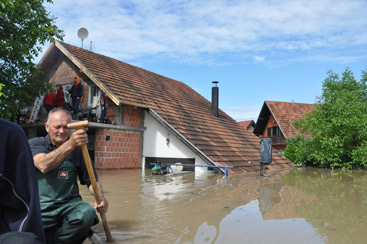
The Danube Flood Risk Management Plan aims to improve prevention, protection and preparedness activities for extreme floods, like the one in 2014 that forced the evacuation of residents in Prud, Bosnia and Herzegovina.
© ISRBC
The Danube River Basin has been the site of many disastrous floods in the past – recent massive floods occurred in 2002, 2006, 2010, 2013 and 2014. From its beginnings, the ICPDR has made flood prevention a priority, and the Danube River Protection Convention recognised the threat when it was signed in 1994. In 2004 the ICPDR adopted the Action Programme for Sustainable Flood Prevention, and in 2009 the first overview of actions to reduce flood risk in the entire basin was published in the form of 17 sub-basin flood action plans.
EU Floods Directive. The EU Floods Directive came into force in 2007, requiring all EU Member States to assess water courses and coastal areas at risk of flooding; map flood extent, assets and humans at risk; and take measures to reduce flooding. In 2010, the ICPDR agreed to implement the EU Floods Directive and develop an international Danube Flood Risk Management Plan (DFRMP) – coordinated by the ICPDR and synergised with the EU Water Framework Directive and the Danube River Basin Management Plan (DRBMP).
Flood hazard and flood risk maps. The DFRMP reviews the conclusions of the preliminary flood risk assessment and maps the areas of potential significant flood risk as well as flood hazards and flood risks of the Danube River Basin District. These maps show the potential adverse consequences associated with various flood scenarios and serve as an effective tool for information, as well as a valuable basis on which to set priorities and plan further technical, financial and political decisions regarding flood risk management. The ICPDR agreed that two scenarios are relevant for the flood hazard map at the level of the international river basin district – flood hazard areas with medium and with low probabilities. The medium probability floods are almost unanimously based on a 100-year recurrence period while the recurrence period of floods with low probability varies mostly from 300 to 1000 years. Overall, the medium probability hazard area covers 32,128 km2 in the basin while the low probability hazard area covers 51,146 km2 in the basin.
The DFRMP includes a number of flood risk maps, showing the population numbers affected by floods, the share of inundated areas by class of economic activity and the potential that the EU Integrated Pollution Prevention and Control Directive and Seveso installations (containing polluting substances) or the protected areas in the basin will be affected by floods.

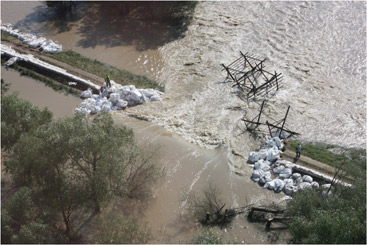
The measures described in the DFRMP address all phases of the flood risk management cycle and focus particularly on prevention (preventing damage caused by floods by avoiding construction of houses and industries in present and future flood-prone areas or by adapting future developments to the risk of flooding), protection (by taking measures to reduce the likelihood of floods or the impact of floods in a specific location such as restoring flood plains and wetlands) and preparedness (providing instructions to the public on what to do in the event of flooding).
© Stanica / ISRBC
Plan objectives
The EU Floods Directive requires Member States to establish objectives for managing flood risks in the areas shown in the flood hazard and risk maps. These objectives must reduce the potential adverse consequences of flooding for human health, the environment, cultural heritage, and economic activity.
Avoiding new risks when planning and implementing activities for urban, rural, and industrial development and construction; agriculture; forestry; and energy and transport. Activities should not increase the risk of flooding, and downstream impacts from upstream activities should be avoided, as should the building of new structures in flood-prone areas.
Reducing existing risks through measures for prevention (such as removing structures from floodplain areas), protection (restoring former floodplains), water flow regulation (dams and reservoirs) or surface water management (catching rainwater).
Strengthening resilience before, during, and after a flood through measures like flood forecasting (such as using radar and satellite imagery), emergency response planning, training flood authorities and disaster assistance (financial and legal, and for the unemployed).
Raising awareness by communicating basic information about flood risks and options for adapting to floods, such as flood risk maps, emergency plans, training on flood preparedness and the involvement of the media.
Applying the solidarity principle to prevent exporting flood risks to neighbouring countries by activities such as retaining rainfall on the spot, storing excess water locally, and transboundary cooperation that enables a rapid exchange of flood data.
Flood risk mitigation measures. To avoid overlap with national plans, the ICPDR agreed that the DFRMP will present only the strategic level measures reflecting activities at the international basin level – this includes measures with a transboundary effect and measures applicable in more countries of the basin. To better demonstrate the key actions of basin-wide importance the measures presented in the DFRMP are combined with the examples of best practices. Annex 2 of the plan lists specific pursuits that consider the initiatives of the EU Strategy for the Danube Region (EUSDR) as well. The projects or project proposals presented in Annex 2 were developed by the ICPDR and/or EUSDR Priority Area 5 and reflect the objectives and priorities set in the DFRMP, have a transboundary character and support the implementation of the needs listed among the measures.
Links to Water Framework Directive. Flood risk management has the greatest potential for synergies with other aspects of water management, provided that adequate strategies are implemented, as traditional engineering solutions (dams, channelisation or dykes) may not always deliver the expected results. In addition, the occurrence of floods may not be reduced completely and the consequences of future floods are likely to have an increasingly social and economic impact. Moreover, floods are a natural phenomenon and high probability floods can have obvious benefits for society and ecosystems, such as for groundwater recharge or fish production. Therefore the DFRMP now promotes another approach of flood risk management – that of integrated flood risk management focusing on prevention, protection and preparedness (including forecasting). In this framework, making space for river and coastal flooding in the areas where human and economic stakes are relatively low is a more sustainable way of dealing with floods. Conservation and restoration of the natural functions of wetlands and floodplains, with their ability to retain floodwaters and reduce the flood pulse, are key features of this strategy, thus allowing important opportunities for synergies with WFD implementation.
Danube Flood Risk Management Plan goes public. At the end of 2014 the DFRMP became available for public consultation on the ICPDR website. A public participation workshop took place in Zagreb in the beginning of July 2015 and brought together over 80 stakeholders from a broad range of backgrounds. Input from the workshop was collected in parallel with the internet-based consultation (Facebook, Twitter, public messages), which gathered more than 50 written comments. Following this public consultation process, the DFRMP was finalised and adopted by the ICPDR in December 2015. Afterwards the ministers and high-level representatives responsible for water management from the Danube River Basin countries and the European Commission endorsed the Danube Flood Risk Management Plan at their meeting on 9 February 2016 in Vienna. They also adopted the Danube Declaration in which they committed to implement the measures of the DFRMP and the national flood risk management plans.
The DFRMP is not only the first technical framework document to address flood risk management over the whole Danube River Basin but also a very useful tool to coordinate and harmonise the national flood risk management practices between Danube countries. It must be highlighted that all of the achievements in managing flood risk sustainably in the Danube River Basin District are the result of a very close and productive cooperation of the Danube flood experts working in the frame of the ICPDR Flood Protection Expert Group. The efficient work of this international body of experts is a prerequisite for proper implementation of the DFRMP in the future.

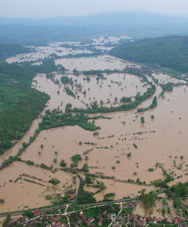
Although natural phenomena, floods cause widespread damage, health problems and even deaths - especially where rivers have been cut off from their natural floodplains, are confined to man-made channels, and where houses and industrial sites have been constructed in areas that are naturally liable to flooding.
© Csaba Csont / ECOVIZIG
Did you know?
To improve flood safety on the Tisza River in Hungary, the Vasarhelyi Plan aims to reduce by 1 metre the 1000-year flood, by constructing 11 reservoirs with a capacity of 1,500 million m3.
A new monitoring system with automatic stations was developed in the Siret and Prut Sub-basins in Romania-Ukraine-Moldova to reduce the vulnerability of communities in border areas.
The advantage of the natural functions of wetlands to supplement flood control infrastructures was utilized in Croatia in the Lonjsko Polje Nature Park where 23,706 ha are used as a natural water retention area.
The Flussdialog (dialogue on rivers)
project was applied to 13 rivers, and has reached an estimated 550,000 people in Austria and Bavaria from numerous stakeholder groups representing policy, administration, economic sectors such as fisheries and energy supply, nature conservation and the public.


